Does Anybody Know What This is?
a rather old object is perplexing a W3 resident
W3 member Mike Abbott writes:
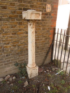
'Having driven past it for decades I finally got to photograph it. But – what is it? It’s in a corner of the recreation area at the junction of Old Oak Road and Acton Lane (near Homebase).
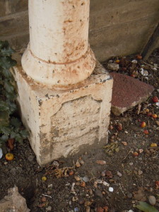
It’s about 4ft tall, looks very Victorian, but so worn that the words wrought-ironed onto it are no longer readable, apart from a year, which looks like 1853.
Perhaps one or two of the visitors to the ActonW3 website have an answer.'
And you do:
On the W3 forum, Vin Miles writes: ''
I don't recall ever seeing anything like this before, but I thought it might be a boundary post, marking a parish or municipal boundary. I dug out a reproduction O.S. map (East Acton and Wormholt, 1913) and saw that there was B.P. marked at that very spot, which stands for boundary post. (The abandoned fish-and-chip shop which the post is right next to was at that time the Bull's Head pub.)
Sure enough, the boundary that runs north-south there is marked "Parliamentary and Metropolitan Borough Boundary" and "Union and Urban District Boundary". One hell of a boundary! And worthy of a nice marker post. I'd like to go and see it and see if the writing can be deciphered .
and Fred Hunt has emailed with another photo:
'The post is a Hammersmith parish boundary marker; I have posted a close up on Flickr - http://www.flickr.com/photos/12043100@N07/3228512249/in/photostream/
Mystery solved!
Contact editor@actonw3.com with any more local info or curiosities - and discuss on the forum.
March 13, 2012